Boston Kayaker

Kayaking on Winooski River - from Plainfield VT to East Montpelier VT


Unrated - The Boston Kayaker does not have enough information or time to make a rating.

  Put in at Recreation Field Rd
  in Plainfield VT.
Take out at Codling Road
  in East Montpelier VT.
Estimated distance
  = 12+ miles
Coburn Road
  Covered Bridge
Kingsbury Branch enters
  on river right.
Main Street
  Dam
  Alternate put in at Route 2
  bridge in Plainfield VT.
Alternate take out at
  East Montpelier Village.
Long rocky
  sections
Green Valley
  Campground
River name from Abenaki
  word meaning "wild onion".
Hidden
  Dam

Disclaimer: It is your responsibility to determine the legality, suitability and safety of this route for yourself.

Download printer-friendly
PDF version that fits in one page:
Kayaking on Winooski River - from Plainfield VT to East Montpelier VT

Other resources:
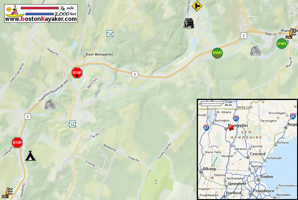
Friends of the Winooski
Friends of the Winooski: Paddling Guide (16mb pdf), see pages 12 to 13
Friends of the Winooski: Paddling Guide (cached copy)
Vermont's Historic State House
Montpelier VT: Hubbard Park


Excerpts from Friends of the Winnooski Paddling Guide (page 13):
Difficulty: Intermediate
Description: This stretch of the river passes by several picturesque Vermont farms and under a covered bridge. The Winooski widens a bit after Plainfield particularly after the Kingsbury Branch enters from the right.
Rapids/Obstacles: This section features two relatively long rocky sections. The first is immediately below the Plainfield Recreation Field put in. The other is on the stretch through East Montpelier village.
Put In:
  • Plainfield Recreation Fields: From Main Street, take Mill Street to the first right, Recreation Field Road. The put in is located at the mouth of Great Brook. Route 2 Bridge (downstream of Plainfield): Less experienced paddlers (or if there is low water) may want to put in here. Parking is along the wide shoulder of Rt. 2. It is an easy walk on a well trod trail to the river.
    Take Outs:
  • East Montpelier Village: There is a takeout on the upstream edge of the Village. Look for a small muddy beach area just as the river bends to the left, away from Rt 2. It is a short but steep climb.
  • Codling Road Access Point (just upstream of Green Valley Campground): You can take out either upstream (on left) or downstream (on right) of the bridge. You can park along Codling Road or in small pull off upstream side of the bridge.
  • Hidden Dam: About a mile beyond the Rt 2 take out is a ‘hidden dam’. Parking for this take out is on a wide shoulder of Rt 2. Recognizing this take out from the road and the river (it is not marked with ropes) is difficult unless you are familiar with the area. The banks are steep with poison ivy.